
We help researchers work with geospatial data for all their research needs.
Contact Information: Steve Gaughan, Research Facilitator / GIS Applications Specialist
![]() stephen.p.gaughan@dartmouth.edu (contact me to schedule a meeting, send questions, etc)
stephen.p.gaughan@dartmouth.edu (contact me to schedule a meeting, send questions, etc)
![]() 603-646-9524
603-646-9524
![]() Locations: By appointment / Zoom / remote, 4 Currier Place, Hanover, NH 03755 map location
Locations: By appointment / Zoom / remote, 4 Currier Place, Hanover, NH 03755 map location
Services (see also examples toward the end of this page) :
- Consulting services, spatial data workflows
- Mapping
- Historical map scanning, data extraction, and transformation
- Geocoding street addresses
- Workshops
- Guest lecturing
- X-hour teaching, case study presentation
- Web-mapping
- Data transformation and data visualization
 ESRI / ArcGIS
  Spatial processing and visualization with R
  Spatial processing and visualization with Python
  SQL database extraction and loading
Geographic Information Systems are systems to create, store, view, edit, analyze, visualize, and export data that is tied to locations on the earth’s surface.
We support and provide GIS software and training, and our GIS Application Specialist offers expert consultations and assistance.
We teach workshops, typically announced in the first week or two of the term. For a list of workshops, see https://rc-new.dartmouth.edu/index.php/training/our-courses/
Research Contributions, Examples & Case Studies
Companion website to “National attribution of historical climate damages”
Published 12 July 2022 in the Journal Climate Change
volume 172, Article number: 40 (2022)
https://link.springer.com/article/10.1007/s10584-022-03387-ythese
https://rcweb.dartmouth.edu/CMIG/national_attribution_2022/prod/
Footprint evidence of early hominin locomotor diversity at Laetoli, Tanzania Published 01 December 2021 in the Journal Nature
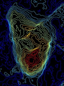
Nature: volume 600, pages 468–471
Ellison J. McNutt, Kevin G. Hatala, Catherine Miller, James Adams, Jesse Casana, Andrew S. Deane, Nathaniel J. Dominy, Kallisti Fabian, Luke D. Fannin, Stephen Gaughan, Simone V. Gill, Josephat Gurtu, Ellie Gustafson, Austin C. Hill, Camille Johnson, Said Kallindo, Benjamin Kilham, Phoebe Kilham, Elizabeth Kim, Cynthia Liutkus-Pierce, Blaine Maley, Anjali Prabhat, John Reader, Shirley Rubin, Nathan E. Thompson, Rebeca Thornburg, Erin Marie Williams-Hatala, Brian Zimmer, Charles M. Musiba & Jeremy M. DeSilva
Nature Volume 600, pages 468–471 https://www.nature.com/articles/s41586-021-04187-7
Surface Contour Extraction, Transformation, and Visualization
National attribution of historical climate damages
Published: 12 July 2022 in the journal Climate Change. Volume 172, article number 40, (2022)

Companion website from Dartmouth’s Climate Modeling and Impacts Group(CMIG). https://rcweb.dartmouth.edu/CMIG/national_attribution_2022/prod/ Callahan and Mankin https://doi.org/10.1007/s10584-022-03387-y
Distribution of maps, charts and data tables (.csv format) programmed using DartFS’s web server, HTML, Javascript, PHP
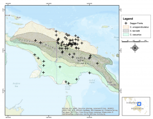
New Guinea bone daggers were engineered to preserve social prestige
Nathaniel J. Dominy, Samuel T. Mills, Christopher M. Yakacki, Paul B. Roscoe, and R. Dana Carpenter
Published 25 April 2018 in the Journal Royal Society Open Science
https://doi.org/10.1098/rsos.172067
Publication-quality maps
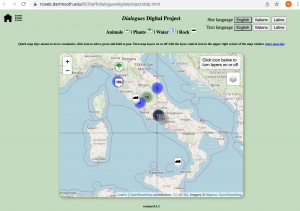
The Dialogues Bioregional Project: Landscape Ecology in Central Italy from the Sixth Century to the Present
Damiano Benvegnù
Published 31 December 2019 in the Journal Humanist Studies & the Digital Age
https://journals.oregondigital.org/index.php/hsda/article/view/4542
DOI: http://dx.doi.org/10.5399/uo/hsda.6.1.5
Web Mapping with Leaflet.js
Machine Learning and Image classification with ArcGIS & Python Code
Data Extraction from scanned historical Maps

Shimásání dóó shicheii bi’ólta’ – My Grandmother’s and Grandfather’s School: The Old Leupp Boarding School, A Historic Archaeological Site on the Navajo Reservation. Two Bears, Davina Ruth. Indiana University ProQuest Dissertations Publishing, Degree Year 2019. https://www.proquest.com/docview/2305191109/abstract/6EE7BC5D6DC840DAPQ/1?accountid=10422
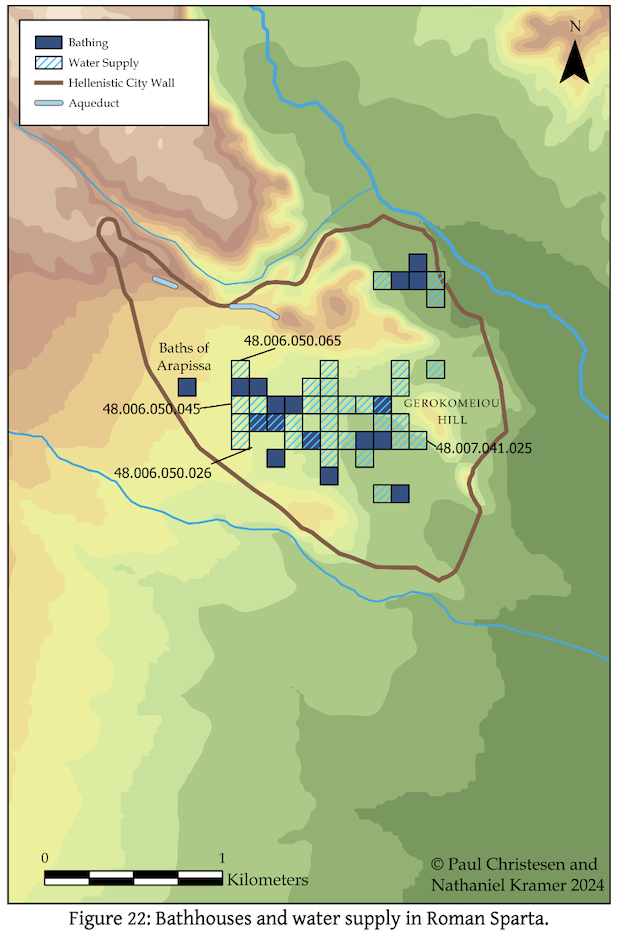
The Settlement Organization of Sparta, from the Bronze Age to the Roman Period. C&M73(2024) 199-294. Paul Christesen & Nathaniel W. Kramer. Classica Et Mediaevalia Danish Journal of Philology and History. Geospatial Database Development
https://tidsskrift.dk/classicaetmediaevalia/article/view/146573
Image: Paul Christesen and Nathaniel Kramer 2024
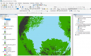
Google Earth Engine

Google Earth Engine Sentinel-2 Remote Sensing time-series data – Scripting with Javascript and Python to analyze satellite imagery
Geocoding street addresses to base maps

We support developing reproducible workflows for research using R and Python with spatial libraries and spatial data.
Workshops
Workshops & topics:
- Spatial Analysis with Python
- Spatial Data in R
- GIS for the Humanities
- GIS for Public Health
- Data Science with Spatial Data & Spatial Analysis Techniques
- Data Wrangling
- Introduction to GIS
- Introduction to ArcGIS
- Up and Running with GIS Projects
- Creating geospatial data: Scanning paper maps, Georeferencing, Geocoding addresses
- Database Design and Query
- Reproducible Research with Spatial Data and Spatial Analyses
- Getting Started with Python
- Getting Started with R
Pre-recorded:
- Spatial Data in R – videos are sequential and ‘chunked’ into short, manageable bites:
- Intro (runtime, 7 minutes, no exercises) https://dartmouth.hosted.panopto.com/Panopto/Pages/Viewer.aspx?id=11563e03-6e31-4620-a264-acb100723a75
- Getting ready to code in R with Spatial (runtime 3 minutes, 10 min with download and install) https://dartmouth.hosted.panopto.com/Panopto/Pages/Viewer.aspx?id=1a01b1c9-fc65-4190-9c45-acb1007238bc
- Coding in R (runtime 5 minutes, no additional exercises) https://dartmouth.hosted.panopto.com/Panopto/Pages/Viewer.aspx?id=c3f3aaaa-ebdb-4ea7-8cab-acb10072397c
- Spatial analysis with R (runtime 19 minutes, ~ 25 minutes total to complete) https://dartmouth.hosted.panopto.com/Panopto/Pages/Viewer.aspx?id=860298e6-78b8-45ce-a171-acb10072448
- ArcGIS – Geographic Information Systems – videos are sequential and ‘chunked’ into short, manageable bites:
- Geographic Information Systems – Slides (runtime 8.5 minutes) https://drive.google.com/file/d/14hXSxjvBRiddwaz2z8hdepMb_gkKtxPx/view?usp=sharing
- ArcGIS Online hands-on tutorial (runtime 12 minutes, ~ 18 minutes to complete https://drive.google.com/file/d/1dsOQBO6U_8UaWkdfyY-hBS0e1jiH1Pmo/view?usp=sharing
Current-term workshops, in-person or via Zoom: https://dartgo.org/RRADworkshops
supported software:
Software as a service: Software-As-A-Service browser-based applications